Anthropologists suggest forts were built to secure key trade routes through the region.
This is the best summary I could come up with:
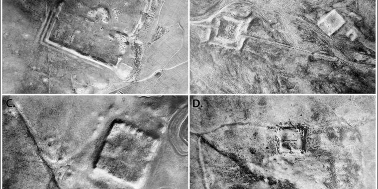
Now, anthropologists from Dartmouth have analyzed declassified spy satellite imagery dating from the Cold War, identifying 396 Roman forts, according to a recent paper published in the journal Antiquity.
A former World War I pilot, he later became a priest and joined the French Levant forces, helping pioneer the use of aerial photography as an archaeological surveying tool to discover and record sites of interest.
Poidebard believed the forts were mostly constructed during the second and third centuries CE as a border wall to defend the eastern Roman provinces from invasions by Arab nomads or Persian armies.
But later scholars argued that the forts were too far apart to function efficiently as a border wall, suggesting instead that they had been used to protect military and commercial caravans in the region—or possibly to defend local populations from nomadic raids.
The authors used declassified imagery from the CORONA and HEXAGON programs to monitor the Soviet Union, China, and other strategic areas from 1959 through 1972—part of the US response to the USSR’s successful launch of Sputnik 1 in 1957.
And in 2006, a team from the Australian National University found evidence of early Islamic pottery factories, along with a hilltop complex of megalithic tombs and the identification of Middle Paleolithic remains at the ancient fortress site of Jebel Khalid in the Euphrates River Valley.
The original article contains 555 words, the summary contains 223 words. Saved 60%. I’m a bot and I’m open source!
Don’t we have much better modern aerial photos?
The article goes into detail about that…
Many forts that Poidebard documented don’t even show up in the 1960s and 1970s spy satellite imagery; the Dartmouth team only identified 36 of his original 116. “The attrition of the archaeological record has been substantial and these processes are unlikely to have slowed over the intervening decades,” they wrote. They believe further research incorporating higher-resolution or even older satellite imagery should reveal many more Roman forts in the region
So they fell over? Got blown up? Buried in sand?
Yeah I don’t know what they mean exactly by “attrition of the archeological record” either, but I assume something like that.